
5th Grade Virtual Tours of U.S. Regions
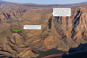 Fifth graders at Holladay Elementary have been learning about the different regions of the United States, so today students in Ms. Sharpe’s class created virtual tours of the U.S. regions using CoSpaces. First, the students selected a region from the five possible choices: northeast, southeast, midwest, southwest, and west. Next, they used their notes and the Internet to research important facts about their region. I also instructed them to find and download a 360 degree photo of an interesting place in their region (search place name + 360 – NOTE: a 360 degree photo will appear somewhat curved). Then we were ready to start creating our virtual tour. We signed into CoSpaces with our Google accounts and created a new project. We clicked the Environment button at the bottom to upload our 360 degree background photo. I showed them how to add 3-D people and objects using the Library. In order to customize the objects’ positions, poses, sizes, and colors, we right clicked on them and selected the appropriate buttons from the pop-up menu. The students added speech bubbles to explain important facts about their regions. We tested our VR scene by clicking the play button (you can move around the scene by clicking and dragging or using the arrow keys). If students weren’t satisfied with where the camera view started out, I showed them how to adjust that with the “Special” button in the Library. Finally we clicked the “Share” button at the top and copied our links into Google classroom so we could view each other’s tours. You can see them all here.