Category: Social Studies

5th Grade Northeast Region Thinglinks

Screen Shot 2015-08-03 at 11.16.05 AM
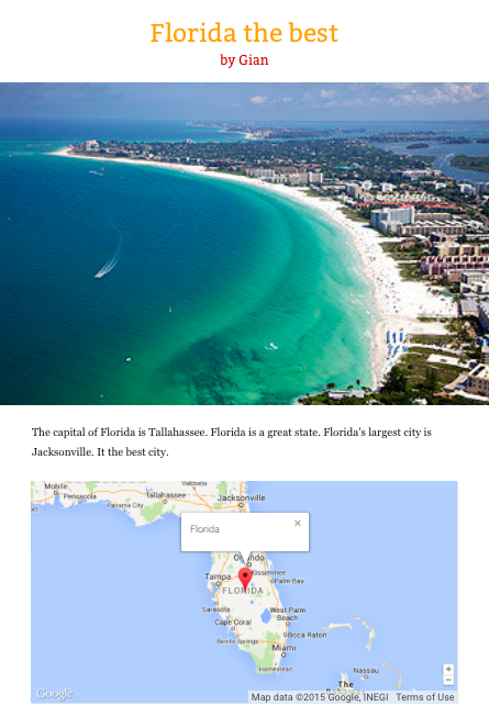
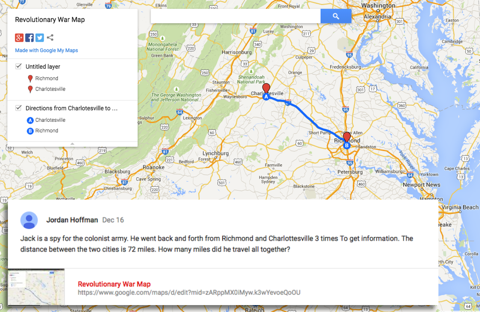
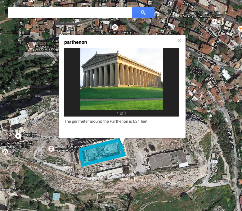
Fifth graders at Davis Elementary have been learning about the northeast region of the United States (NE1.2, NE2.2), and they have been learning how to write to inform (SOL5.7). So today, students in Ms. Bailey’s class created interactive Thinglink maps highlighting some of the interesting places in each state. First we needed to get a map of the northeast region. I gave them a link to Google maps and showed them how to choose either the standard view or a satellite image (click the box in the bottom left corner). Once they had the map centered on the northeast region, I showed them how to take a screenshot using the Snipping Tool. Then we went to Thinglink and logged in with our Google accounts. The students uploaded their map and added hotspots to different cities in the northeast region that they had been researching. For each hotspot, I taught them how to customize the icon, upload an image, and write an informative paragraph about the place of interest. We only had time to do one or two places, but Ms. Bailey continued the project with her class, and they were able to add several more on their own. You can see their final projects here.


4th Grade Pixiclip Videos

Screen Shot 2015-06-01 at 10.21.20 AMFourth graders at Varina Elementary have been learning how to multiply 2-digit numbers (SOL4.4b), so today students in Ms. Burcham’s class created their own “how-to” videos explaining how they do it. As students create their videos, they have to break the process down into steps and explain each step. Not only is this valuable for the students, but it also helps the teacher see how the students are thinking each step of the way. They can identify exactly where in the problem solving process misunderstandings occur. Another benefit of creating “how-to” videos is that students can go back to the videos later if they need a quick review. We used a webtool called Pixiclip to record our videos. It’s a great tool that doesn’t require a login. You can record audio or video and you can draw, type, or upload files on a virtual whiteboard. First the students created their own multiplication problem to solve. I encouraged them to challenge themselves though, and not make it a simple problem. Next they chose the strategy they would use to solve it and recorded their steps. Those who finished early went on to make videos showing where the different people groups settled in Virginia (VS.4b), since they are studying colonial times in Social Studies. I gave them a map to use to save some time. We posted all our links to Google classroom, but you can see some of their videos by clicking here.


5th Grade Northeastern State Comparisons

Screen Shot 2015-05-21 at 10.37.30 AMFifth graders at Davis Elementary have been learning about the northeastern region of the United States (NE1.1, NE2.2b). Their benchmark tests also revealed that they need extra practice with collecting, organizing, and interpreting data (Math SOL5.15). So today students in Ms. Elsea’s class gathered data about the northeastern states and presented their information with infographics. First, I instructed the students to choose two northeastern states to compare. We used Measure of America to get data about the population, education, economics, health, or whatever topic the students wanted to compare for their two states. Next we went to Piktochart to make our infographics. I showed them how to change the background and choose a font and color scheme. I encouraged them to use just a few colors and to be consistent with the colors across all the graphics and text. One of the first graphics we added was a map showing our two states. Then we added a pie chart comparing the data we had gathered, and I showed them how to add clip art that related to their data. Some students were able to add several graphics. Finally, we copied the links to our infographics, and posted them to our Google classroom page so we could see each others’ presentations. Take a look at some of them here.


5th Grade Facts and Opinions

Screen Shot 2015-05-13 at 2.24.28 PMFifth graders at Holladay Elementary have been learning about the states in the southeastern region of the United States (SE2.2b,c), so today students in Ms. Filer’s class created websites about a southeastern state of their choice. Since they had recently completed their benchmark tests, I was looking at the data, and I noticed that many fifth graders had a hard time identifying the point of view of the author and distinguishing between facts and opinions (SOL 5.5f, 5.6i). So I wanted to include those skills in my lesson as well. First we talked about point of view and how to identify the author’s point of view. Did the author have a positive or negative view of the topic they were writing about? Since our websites would be about a place, we looked at some online reviews for a local place, the Lewis Ginter Botanical Gardens. It was fairly easy to identify the author’s point of view by the words they used. Clearly some people enjoyed the gardens, while others did not. Next we practiced identifying facts and opinions in the reviews. I pointed out that usually a review could be considered more reliable if it included facts, instead of just opinions. We discussed where we should go to get the most reliable facts. Would the Botanical Gardens website be the most reliable, or could it be biased? I explained that the students would be creating a website about a southeastern state, and they would have to include facts and opinions, so it would be best if they had actually been to that state. I pointed out that the reader should be able to identify your point of view and tell whether you had positive or negative feelings about the state. The students could research their state using books or websites, and we used Tackk to create our websites. Tackk allows them to add text, maps, and photos of their state. After creating their websites, they posted the links on Google classroom with a question for their classmates to identify the facts, opinions, and viewpoint. Take a look at some samples here. This lesson was also submitted to Henrico21, so if you’d like to see the complete lesson plan, click here.


4th Grade Multiplication Maps

Screen Shot 2015-05-14 at 11.51.39 AMFourth graders at Holladay Elementary have been learning about life in colonial Virginia and the Revolutionary War (VS.4,VS.5), and they’ve been learning how to multiply two digit numbers in math (SOL4.4), so today we made multiplication maps about colonial Virginia in Ms. Ficor’s class. First we discussed which major cities existed during this time (Norfolk, Richmond, Williamsburg, Yorktown). We also talked about what activities would require colonial people to travel from town to town (trading, spying, fighting, visiting). I explained that they would be creating maps with a story problem to solve. They would have to figure out the distance between two towns, tell why a colonist was traveling back and forth between those towns, and tell how many times that person made the trip. Then their classmates would solve each others’ problems. I posted a link to My Google Maps on their Google classroom page. The students placed markers on the two towns their colonists were traveling between and then clicked for directions. A blue line is automatically created with the distance. I showed how they could change the mode of transportation to walking. Next they shared their maps and copied the link to post to the classroom page. They wrote their story problem in their post, and their classmates solved them in the comments. I pointed out that they needed to solve their own problems, so they could check the answers. You can try out some of their problems here.


3rd Grade Parthenon Perimeter

Screen Shot 2015-05-12 at 8.02.58 AMThird graders at Davis Elementary have been learning about the architecture of the ancient Greeks (SOL3.1) and how to identify Greece on a map (SOL3.4). They have also been studying perimeter in math (SOL3.9d). So today students in Ms. Eller’s class found the Parthenon using Google maps and calculated the perimeter of it. First we signed into our Google accounts and went to Google classroom where I posted a link to My Google Maps. The students clicked “Create a Map,” and we talked about where Greece was located. First we found Europe, then we located the Mediterranean Sea. Since the map was labeled, it was easy to find Greece. We zoomed in on Greece, and I instructed them to keep zooming in on the labeled city of Athens. Once they were closer to the city, we started zooming in on a green patch labeled “Acropolis.” Then we switched over to Satellite view (click Base Map in the left menu box). Now we could actually see the Parthenon and its columns! By the way, if you would like to give your class a virtual tour of the Parthenon you could go to it in regular Google maps and drag the yellow peg man from the bottom right tool bar to one of the blue dots that appear near the Parthenon for a Street View panoramic tour of the site! To calculate the perimeter of the Parthenon you could use the ruler tool and measure all the sides, but we used the line tool and drew a rectangle around the Parthenon. I showed them how to change the color and thickness of the shape using the paint bucket that appears next to the shape in the left-hand key. When you click the shape after you’ve saved it, a box pops up that gives you the perimeter. We clicked the pencil on the box to edit it and wrote the perimeter in the description (other people who view the map won’t see the perimeter unless it’s in the description). We also clicked the camera tool to add a photo of the Parthenon. We posted the links to our maps in Google classroom so we could compare our measurements with our classmates’. You can look at some of their maps here.


1st Grade Goods & Services

chefFirst graders at Davis Elementary have been learning about goods and services (SOL1.7) so today students in Ms. Long’s class created Pixie drawings showing what they want to be when they grown up and telling whether they would provide goods or services. They used the brush tool to paint parts of the picture, but they also used clipart from the Stickers library. Then they added a photo of themselves with the webcam tool. The last step was to type a sentence identifying their job and the goods or services they provide. We exported their pictures as .jpg images, and I showed them how to upload the files to their Google classroom page. Since the classroom page is private, I also uploaded them here for you to see.


Tags:


2nd Grade American Indian Math

Screen Shot 2015-05-12 at 10.01.42 AMSecond graders at Davis Elementary have been learning about three American Indian tribes: the Powhatan, the Lakota, and the Pueblo Indians (SOL2.2). They have also been learning how to solve and create their own addition and subtraction story problems (SOL2.21). So today students in Ms. Vest’s class created story problems about American Indians. First they chose a tribe, then we opened Pixie, and I showed them how to add stickers and paint to make a picture of the tribe. We discussed features to include like the landscape, their homes, the animals they hunted, and the modes of transportation they used. We exported the finished pictures as .jpg files, then we posted them to our Google classroom page. I instructed them to type a story problem to go with their picture. Then their classmates could try solving the problems and writing the answers in the “Comments” section. You can take a look at some of their problems on Padlet.


Tags:


3rd Grade Ancient Greece Word Problems

PursellThird graders at Laburnum Elementary have been learning about the contributions and the economy of the ancient Greeks in social studies (SOL3.1, 3.7), and they’ve been learning how to solve multiplication word problems in math (SOL3.6). So today students in Ms. Ford’s class wrote their own ancient Greece multiplication word problems for their classmates to solve. First I created an assignment in Google classroom and gave them a blank Google docs template. Since this was their first time using Google docs, I showed them how to change the font, size, and color of the text. They added a customized title, then we brainstormed ideas for the multiplication problem. We discussed what the land and architecture in ancient Greece were like, and we also considered the different jobs that people in ancient Greece had. I explained that multiplication involves groups of things, so I told them to think about situations in the lives of the ancient Greeks that would include groups (soldiers, Olympics, trading ships, olive and grape orchards, buildings, etc). They typed their questions, then I showed them how to add a picture using the built-in Google image search. We posted the problems to the Google classroom page so the students could solve each others’ problems. You can try solving some yourself here.


2nd Grade American Indian Problems & Solutions

Screen Shot 2015-05-08 at 1.58.37 PMSecond graders at Holladay Elementary have been learning about the Powhatan, Lakota, and Pueblo Indian tribes in Social Studies (SOL2.2), and they’ve been learning how to identify the problem and solution in fictional texts in Language Arts (SOL2.8f). So today students in Ms. Coyle’s and Gardner’s classes created comics about the American Indians and included a problem and solution. First I posted a link to StoryboardThat on their classroom page and instructed them to choose an Indian tribe for their story. Next we discussed problems that the various Indian tribes might have. The students mentioned sickness, war, weather, drought, animals, and more. They had lots of ideas! As the students thought of a problem and solution for their story, I instructed them to look at the different Scenes and find a good setting for the tribe they selected. The “US History” tab has examples of longhouses, tipis, and multi-storied terraced buildings. The “Outdoor” tab has examples of woodlands, grasslands, and deserts. Then I showed them how to find American Indian characters under the “1600s to 1800s” tab and how to customize their skin, hair, eye color, facial expressions, and poses. After the students had their drawings in place, they added speech bubbles and typed sentences explaining the problem and solution. Finally they posted the links to their comics on the Google Classroom page with a question for their classmates to answer. You can take a look at some examples here.