Tag: GoogleEarth

Kindergarten Google Earth & Maps
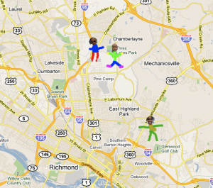
Today Ms. Hall’s kindergarten class at Laburnum Elementary used Google Earth to locate their school. We even zoomed down so close that we could see the U.S. map on the blacktop! Next we tried to locate their houses. Ms. Hall has been working with them on memorizing their addresses, so this was a great way to practice. They would tell me their address and I would enter it into Google Maps and put a pushpin where they lived. Then they drew an icon of themselves in Pixie and we used those icons to replace the pushpin. So in the final map, you can see a picture of the student in the location where they live (click on the picture…I can’t show the embedded Google map because it has the addresses of students, but it’s an actual interactive Google map that you can click and drag and zoom and explore)!


Teacher Spotlight – Scott Hook

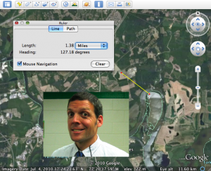
Scott Hook, a new fifth grade teacher at Holladay Elementary shared a great idea with me via email: “I wanted to just send a note mentioning that I found success with Google Earth in the classroom. We are covering Metric Measurement in Math and Google Earth has a great RULER feature that measures to the nearest NANOmeter. I have a Promethean Board in the class and we projected a great view of our school (Holladay ES). We made estimates about the length of the parking lot (“Would we use centimeters, meters, or kilometers?”). Then we used the Ruler tool to measure very accurately. We did this for several objects around the school (cafeteria, bus loop, dumpster), a few kids live close by and we measured their houses. Then we discussed where some of our students’ families were from. We “visited” them on Google Earth (Morocco, Vietnam, El Salvador, Iceland, Baltimore) , then made estimates as to how far the places were from Holladay. We would measure in kilometers, then I asked the kids to convert to meters, and then centimeters. It gave good practice in reading numbers up in the billions as some of the distances in centimeters were quite far. It was a chance to make ESL students feel unique, covered a slew of objectives, and incorporated technology.” Thanks a lot for sharing Scott, and if any other teachers have successful technology lessons, please share them with me!


1st Grade Maps Keynote

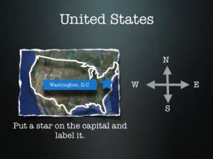
This maps activity is similar to the Kindergarten Keynote I did last week, but it is more geared towards the first grade SOLs (1.4) where they need to identify the capital of the United States and the capital of Virginia. So first we looked at them in Google Earth. I took screenshots of the places and put them into the Keynote template that you can download by clicking here. The students also identified their classroom at their school (Trevvett in this case, but you can change that slide to fit your school). On each slide the students labeled the cardinal directions as well. If you’d like to see a finished sample, click here (you will also need to click to advance the slides in the online version).


2nd Grade China & Egypt Kidspiration

Second graders wanted a way to review the ancient civilizations of China and Egypt before the end of the year tests. So I created a sorting activity in Kidspiration that you can download here. Students drag the different contributions into the correct box depending on whether it was Egyptian or Chinese. When they are finished sorting, they switch over to the writing view (click on the pencil button in the top left corner) and notice that it is outlined for them already. Then they write a sentence about each contribution. While you’re reviewing China and Egypt why not take them to Google Earth and zoom down to see the Great Wall and the pyramids!


Kindergarten Maps & GoogleEarth

Today in kindergarten at Chamberlayne Elementary, students worked on creating Keynote slideshows about maps (K.4, K.5). First I showed them Google Earth so they could get an idea of how maps are made. We zoomed down and found their school. This is a fantastic tool to use with all grade levels but especially with lower grades because they can actually see familiar buildings and roads from above. I used screenshots from Google Earth to make the Keynote template which the students opened next. You can download it by clicking here. The template already has directions and some built-in animations, so students just need to follow the directions on each slide and press play. You can see a sample by clicking here. If you have time, a good idea would be for the students to use the audio record feature of Keynote to record themselves explaining each slide.


Google Earth & Shapes of Kazakhstan

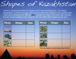
Inspired by my friend Frank’s post about finding 3-D shapes in Google Earth, I looked for a city that has buildings with all the different shapes our students need to know (cylinder, cone, sphere, pyramid, cube, rectangular prism SOL 3.18, 4.17, 5.16). Astana, Kazakhstan fits the bill. Open Google Earth, fly there by typing “Astana” and look south of the city for a unique layout of interestingly shaped buildings. You should be able to find all of the shapes within a 2-mile radius by using the navigation controls (be sure 3D buildings is checked in the Layers). As the students find each shape, instruct them to use the ruler tool and measure the height of each building, then enter their data on the sheet which you can download here or if you want to see the PDF version, click here. If your students are having trouble finding the shapes, you can cheat by downloading the KMZ file here. The KMZ file will load the places into Google Earth and if you click them you will get a tour that looks kind of like this. If your students would like to learn more about Astana, Kazakhstan, I created a website here to describe the buildings a little more, and it also includes an interactive map. If you find any more interesting-shaped buildings let me know!


Google Earth & The Great Dismal Swamp

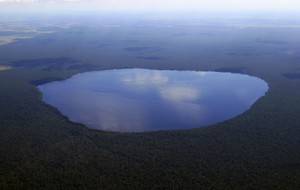
LakeDrummond9Fourth graders have some new places they need to know for the SOL Test this year, and two of them are the Great Dismal Swamp and Lake Drummond. I have gathered together some pictures of these places for you to use for classroom projects. You can download the folder of pictures by clicking here and you can view the swamp and lake in Google Maps by clicking here. At Holladay today we went to Google Earth (it’s on all student computers) and typed “Lake Drummond” in the search box. It will zoom right into the lake and then students can click on the blue squares and see photos people have taken. You should try it with your class!