2nd Grade Maps Pixie
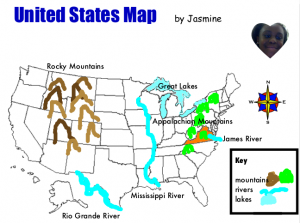
 Today second grade students at Pinchbeck Elementary were reviewing their United States map skills (SOL 2.5b, 2.6) with Pixie. I gave them a template to use which you can download by clicking here. First students used the paint tool to draw the rivers on the map (Rio Grande, Mississippi, and James), then they added the symbol of a river to the map legend. Next they drew the Appalachian and Rocky Mountains on the map and added the mountain symbol to the legend. Finally they used the paint bucket tool to fill in the Great Lakes and Virginia. They also dragged the labels into the correct locations. We used the compass rose to ask directions about the location of different features. For example, “Is the Mississippi River east or west of the Rocky Mountains?” It was a great way to review maps and introduce Pixie at the same time. Another 2nd grade map skill is identifying the continents and oceans (SOL 2.5a). If you’d like to try a Pixie lesson for that skill, click here.
