
3rd Grade Perimeter & Ancient Architecture
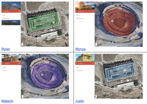 Third graders at Trevvett Elementary have been learning about ancient civilizations in History (SOL3.3) and how to measure perimeter in Math (SOL3.8a), so today, students in Ms. Robinson’s class measured the perimeter of the Parthenon and the Colosseum with Google Maps. First, we explored both structures in Google Earth. Google Earth is an amazing tool that not only allows you to view buildings in 3D, but you can actually look around inside them with 360 photos (click the little man icon in the lower right corner, then click on a blue dot near a building). As we explored each building, we estimated their perimeters. Next, we went to My Google Maps. Google Maps has a different set of features that allows you to create and save your own custom maps. We located the Parthenon and the Colosseum and placed a marker on each one using the marker tool. I showed them how to customize the pin by typing information, adding a photo, changing the pin color, and adding an icon. Then we used the shape tool to draw a shape around the perimeter of each building. Shapes can be customized as well, using the paint bucket tool to change their color, border size and transparency. Once the “Save” button is clicked, the perimeter and area of the shape can be found in the bottom of the pop-up box. Students compared their earlier estimates with the actual measurements. Finally, we published our maps and shared them on Schoology. You can see them all here.