
4th Grade Jamestown Maps
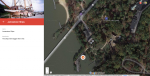 Fourth graders at Trevvett Elementary have been studying Jamestown, the first permanent English settlement in America (VS.3), and they recently took a field trip there. Today students in Ms. Harlow’s class reflected on their trip and what they have learned. I posted a link to My Google Maps on Google classroom. My Google Maps allows you to create your own map (you can also access it through your Google Drive by clicking New > More > Google My Maps). We titled our map “Jamestown,” and I showed them how to find Jamestown by zooming instead of using the search box. First, we switched to Google Earth view (click the box in the bottom left corner) and zoomed into Virginia. Then we found the James River and zoomed into one of the big bends in the river. As we zoomed in, we saw Jamestown appear on the north bank. We continued to zoom into Jamestown until we saw the park and the dock. Students were amazed that they could actually see the ships, the fort, and the Powhatan Indian village. They already knew that the park isn’t the true location of Jamestown, but we were able to find the true location nearby. I showed them how to add markers to different parts of the map. They wrote a description for each marker, explaining what they learned or what surprised them at that spot. I also showed them how to click the camera button and add a photo. Finally we gave our map some finishing touches by customizing the markers (click the paint bucket, and you can change its color and the icon on the marker). We clicked the Share button and shared our maps with “anyone with the link.” The students posted their links to Google classroom, but you can see them all here.